
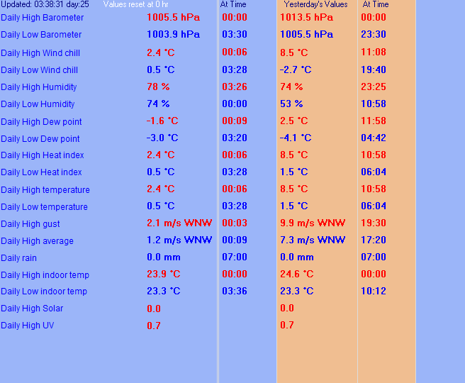
| LAST READING AT TIME: 00:50 DATE: 14 December 2009 | |||
|---|---|---|---|
| Current Weather | Dry | Current Temperature | 3.1°C (37.6°F), Apparent temp 1.0°C |
| Maximum Temperature (since midnight) | 3.1°C at: 00:01 | Minimum Temperature (since midnight) | 3.1°C at: 00:01 |
| Average windspeed (ten minute) | 0.7 m/s | Wind Direction (ten minute) | E (94°) |
| Windchill Temperature | 3.1°C | Maximum Gust (last hour) | 1.8 m/s at: 00:04 |
| Maximum Gust (since midnight) | 1.8 m/s at: 00:05 | Maximum 1 minute average (since midnight) | 1.8 m/s at: 00:05 |
| Rainfall (last hour) | 0.0 mm | Rainfall (since midnight) | 0.5 mm (0.02 in.) at 20:15 |
| Rainfall This month | 62.7 mm (2.47 in.) | Rainfall To date this year | 1017.3 mm (40.05 in.) |
| Maximum rain per minute (last hour) | 0.0 mm/min | Maximum rain per hour (last 6 hours) | 0.0 mm/hour |
| Yesterdays rainfall | 1.6 mm | DewPoint | 1.8°C (Wet Bulb :-3.3°C ) |
| Humidity | 91 %, Humidex 1.4°C | Barometer corrected to msl | 1024.4 hPa |
| Pressure change | -1.1 hPa (last hour) | Trend (last hour) | FALLING |
| Pressure change (last 12 hours) | -11.0 hPa | Pressure change (last 6 hours) | -3.1 hPa |


Use the RELOAD facility on your browser to retrieve the latest data.